
Individuals
Record view
While the individuals table provides an overview, the individual record view has more options. It can be reached from the table by tapping on a record or using the second button on top (for a new entry).
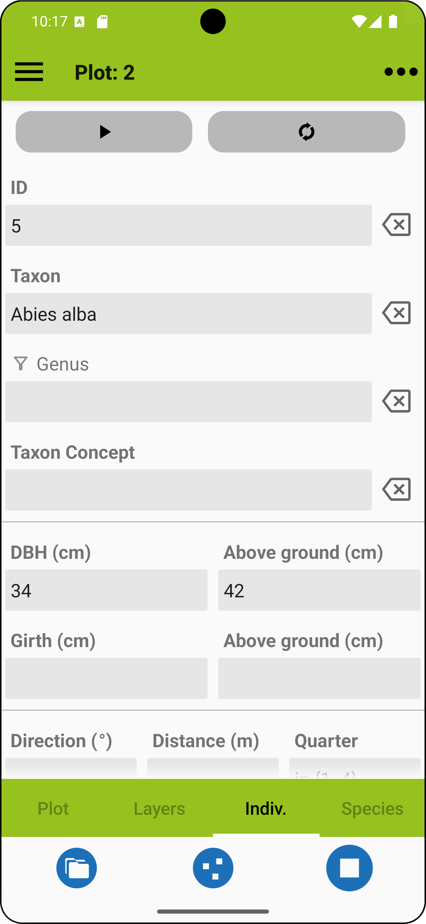
The fields in this view are explained in the table below. If you have finished your entries you can add another individual using the arrow button on top (pointing to the right) or, in case you enter another plant from the same species, you can use the recycle button. The ID field is filled in automatically, but you can change the suggested ID.
The fields are partly optional and can be activated / deactivated in the project profile. It is also possible to add up to ten (custom fields).
| ID* | A unique ID for the plant |
| * Taxon | Tap in the field and start to enter genus and species abbreviations to narrow down a selection of taxon names (like p ann for Poa annua). Make sure to enter a valid name or synonym from the active species list. You can also long-press the taxon field and a list of already entered taxon names shows up. If you use the genus filter below the field turns into a species selection field. |
| * Genus | If you use this genus filter the taxon field turns into a species selection field. Instead of entering a genus you can long-press the field and a list of already entered genus names shows up. |
| * User taxon concept | For example the flora you used. This clarifies what the name actually refers to. The entry is recycled at the next species entry. |
| * DBH | Diameter at breast height in cm. |
| Girth | Girth in cm. |
| * Above ground (m) | Height of measurement above ground (for DBH and girth). |
| Direction | Direction for specifying a relative position (along with distance). |
| Distance | Distance for specifying a relative position (along with direction). |
| Quarter | Quarter to be used in methods such as the Point-Centred Quarter Method (PCQM). |
| Location | Spatial coordinates of the plant individual. These coordinates can be measured using the device's GPS module by tapping on the marker button. An additional line appears showing the current GPS accuracy, and you can confirm and save the location directly from there (see more about locations here). |
| Custom fields | You can add up to ten custom fields related to individuals. Please refer to the custom fields section if you want to learn more about this option. |
| Protocol | Observed measurement protocol. The field can be filled in the project's profile. |
* Attribute visible by default
 |
Add another individual. |
 |
Enter another individual from the same species. |
 |
Set cf. (uncertain identification) for genus or species. |
 |
Add an ad hoc species (see separate explanation below). |
 |
Capture a photo. Photos can only be added once a taxon name has been entered. |
 |
Browse project photos. |
 |
Toggles for turning on or off: - Confirmation prompts - Synonyms in species selection. |
Ad-hoc species
If a species is missing from your species list you can add an "ad-hoc species". It will be accessible across projects and exported along with the project. If you want to get rid of accumulated ad-hoc species, you can delete them from the right menu.
Fields for ad-hoc species entries
| Genus* | Latin name of the genus like Cocos in Cocos nucifera |
| Species* | The rest of the name except for the author citation. This field usually takes the latin specific epithet like nucifera in Cocos nucifera but it may also contain intraspecific epithets and connecting terms denoting the rank like "subsp.". Also, terms indicating the width of species concepts like "s.str." or "s.l." and other abbreviations like "agg." go here. |
| Scientific | Checkbox indicating whether this is a scientific name (mainly required for export to VegX) |
* Required
Vegapp supports user taxon views, meaning that values for author and secundum (sec.) are not needed anymore (you may enter NA for not available).
HOME UP
Privacy Policy, Contact, Impressum